

_Tony Grubesic
Grubesic is a professor in the College of Computing & Informatics with a joint appointment in the Department of Sociology. Serves as co-director of the Center for Spatial Analytics and Geocomputation.

_Alan Murray
Murray is a professor in the College of Computing & Informatics and in the School of Public Health. Serves as co-director of the Center for Spatial Analytics and Geocomputation.
Almost all data has a “where.” Information is connected to a place and time and can answer questions about a city, a building or system. Through spatial analysis, researchers are able to understand where phenomena are, how they relate and what it may mean for policymakers.
At Drexel’s recently established Center for Spatial Analytics and Geocomputation in the College of Computing & Informatics, Tony Grubesic and Alan Murray are examining datasets with the tools of their field — geographic information science, statistics, mapping software — to influence deliberations on topics such as liquor privatization, urban lighting and safety, and the optimum number of rural airports.
“Most data has a spatial component,” says Grubesic. “We leverage that data to help decision makers craft better policy and to enhance operations.”
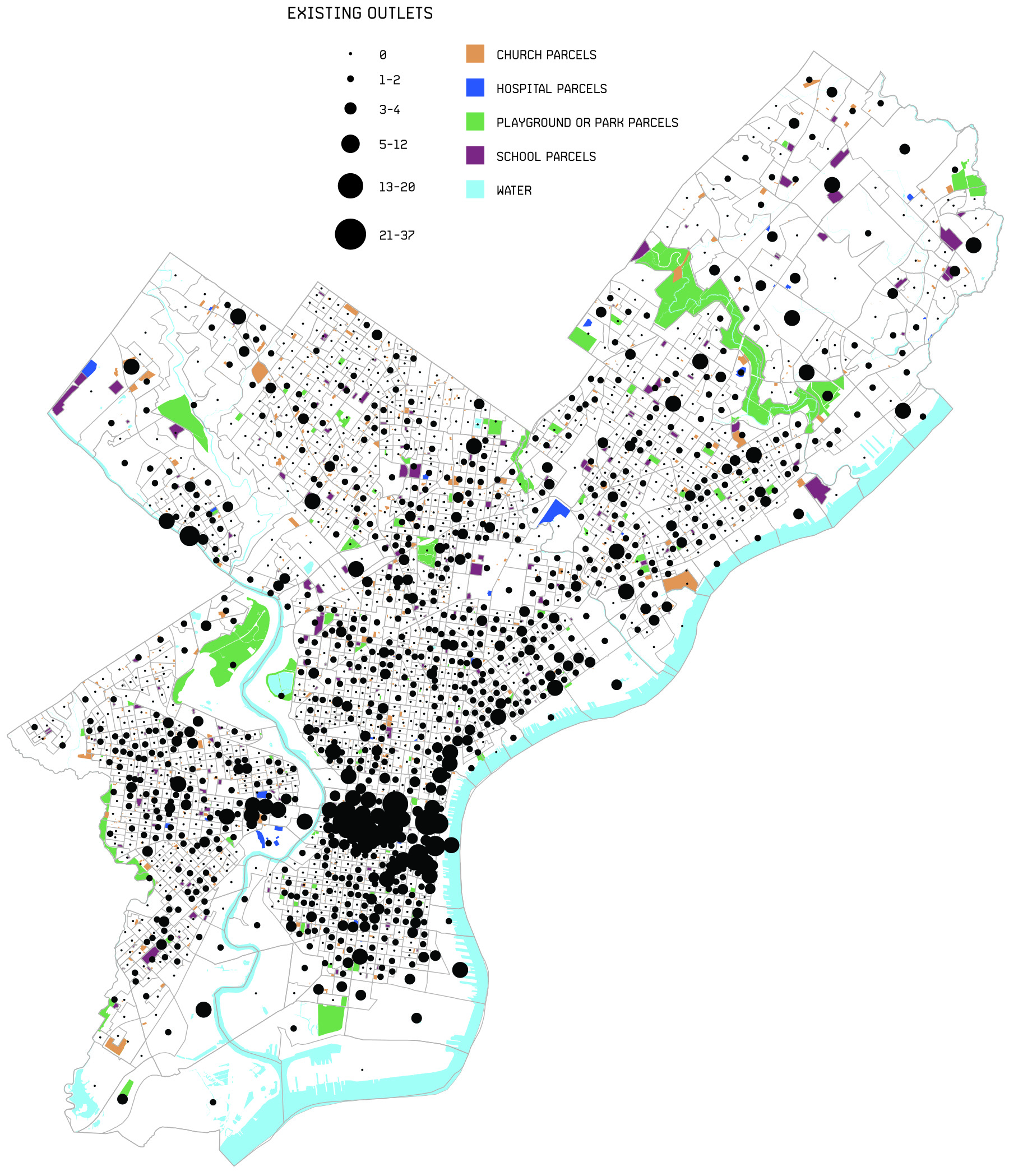
WATERING_HOLE
Like many cities, Philadelphia has a proximity rule that bans liquor stores within 200 feet of any church, school, hospital or playground; geospatial analysis shows that the rule leaves plenty of room for more outlets.
Crime Uncorked
In a two-year project funded by the National Science Foundation, Grubesic and Murray used geospatial data to evaluate how alcohol outlets impact cities.
In Cincinnati and Philadelphia, they found different patterns of violence near on-premise alcohol outlets (like bars where the alcohol is consumed on-site) and off-premise outlets (like corner stores, where alcohol is consumed elsewhere). Crime rates were higher near places where customers of off-premise outlets gathered to drink, such as vacant lots.
They then asked what this might mean for Philadelphia if the city privatized liquor sales. Like many cities, Philadelphia has an ordinance that restricts alcohol sales near churches, schools, parks, etc. Alcohol availability is associated with violence, car accidents, child abuse and neglect, and youth suicide.
“Communities are trying to maintain standards,” says Grubesic.
They found that privatization could lead to a nearly 60-percent increase in alcohol outlets, or an additional 1,115 outlets, given the city’s 200-foot proximity rule.
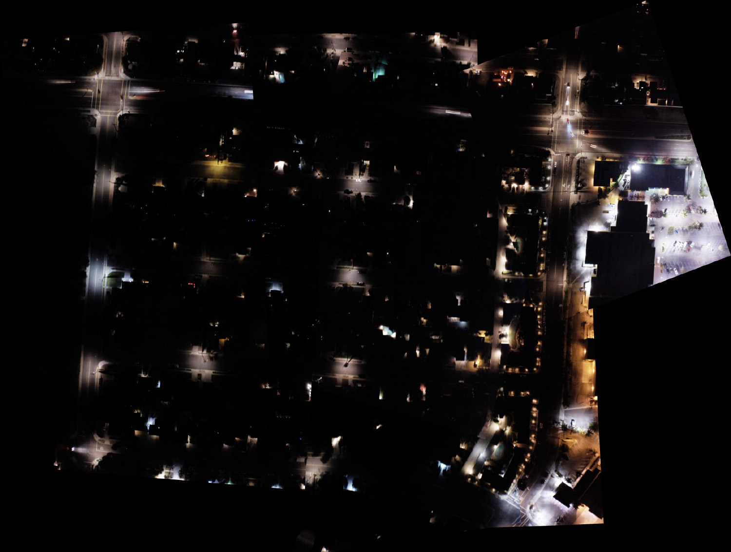
Patch_work
In order to study the lighting over a San Diego neighborhood, researchers compiled individual images taken by aerial drones and pieced them together into a single map.
Checkered Streets
The need for well-lighted urban streets is often at odds with the desire to curb light pollution.
Murray studied aerial photographs of a San Diego neighborhood at night using a series of high-resolution images from a drone camera — shooting not just once every six months or per year as many satellite mapping systems do, but daily — to observe how nighttime lighting varies across a neighborhood.
“Nighttime lighting enhances safety and security for a home or neighborhood as well as contributes to the charm and character of an area,” says Murray, “yet artificial light has been found to negatively impact humans and animals in a variety of ways.”
The images pinpointed where light posts are needed, and where light already being generated by businesses satisfies requisite needs, offering potential to save money while also contributing to public safety.
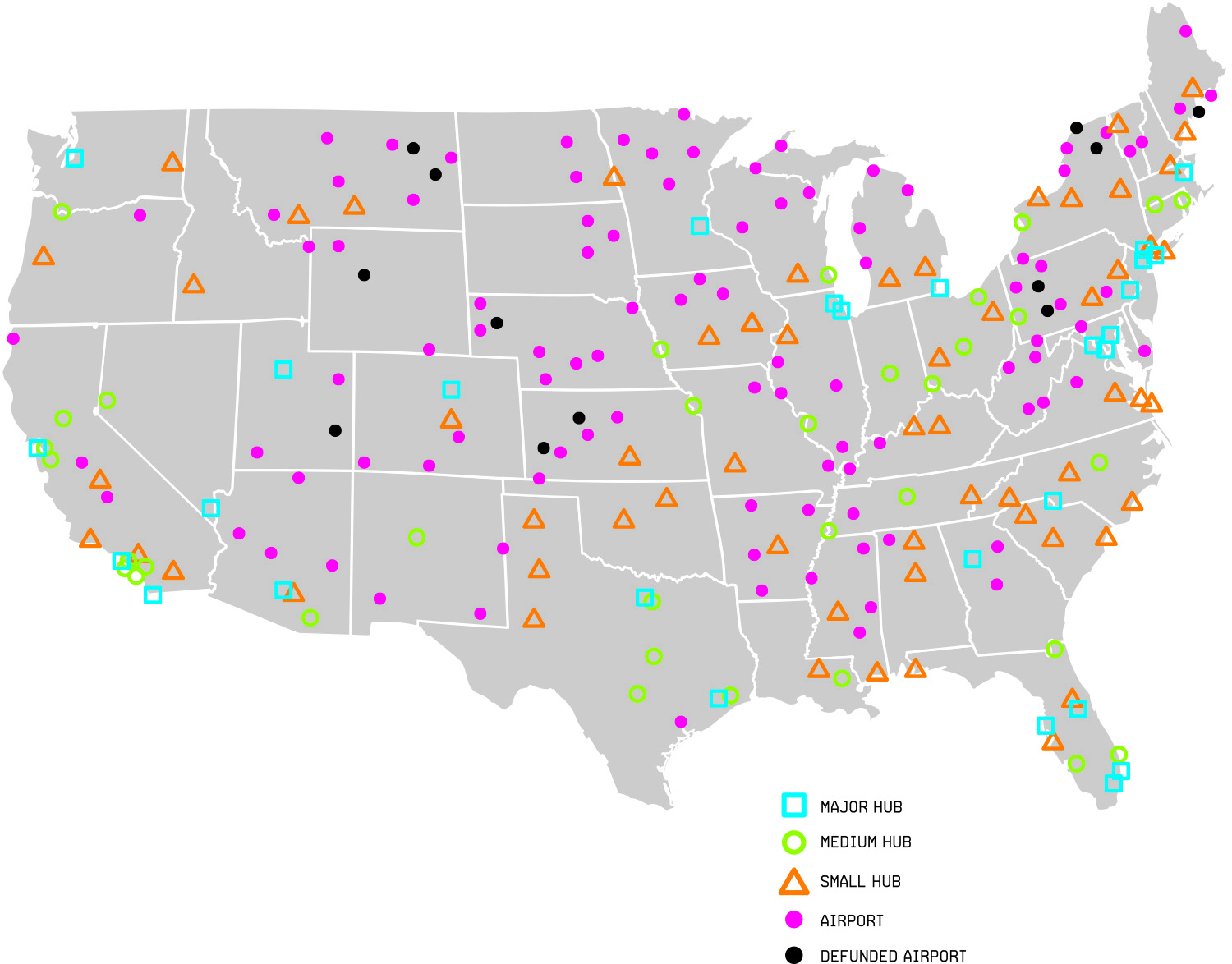
Prop_Planes
By closing certain rural airports, taxpayers could save nearly $22 million a year, with almost no impact on service.
Flights to Nowhere
How do you balance transportation access with the cost of servicing remote areas?
Grubesic and Murray analyzed a federal program that pays commercial air carriers to provide service to rural airports. The program grew out of a temporary financial bridge created to maintain commercial air service in rural communities following 1978 airline deregulation, but it has grown into multi-million dollar federal subsidy.
“The question is: Is there a way to ensure that the people and businesses who need this service still have some semblance of commercial air transport, but do it in a more efficient way?” Grubesic asks.
Through a spatial optimization model, they found that 99.7 percent of potential residents would still be served if the government defunded certain airports in areas that were already being adequately serviced, saving taxpayers nearly $22 million per year.