
_WINN COSTANTINI
Costantini is a scientist in the Academy of Natural Sciences’ Patrick Center for Environmental Research.

_ROMAN PEREZ
Perez is a scientist in the Academy of Natural Sciences’ Patrick Center for Environmental Research.

_ALEXIS SCHULMAN
Schulman is assistant research professor in the Department of Biodiversity, Earth and Environmental Science in the College of Arts and Sciences.
Philadelphia’s urban landscapes veer between extremes — leafy parks in West Philadelphia, dusty lots in Kensington — that mirror the unequal environmental burdens residents face. During the mayoral race of 2023, a coalition of environmental and neighborhood organizations launched the Green Living Plan to encourage the candidates to prioritize policies around air and water pollution, green spaces, and green jobs and services. But advocacy alone wasn’t enough — leaders needed clear data to show where investments could make the biggest impact.
That data came from the work of researchers at the Academy of Natural Sciences’ Patrick Center for Environmental Research, in collaboration with Drexel’s Environmental Collaboratory. Together they developed a powerful data tool: the Environmental Justice Index.
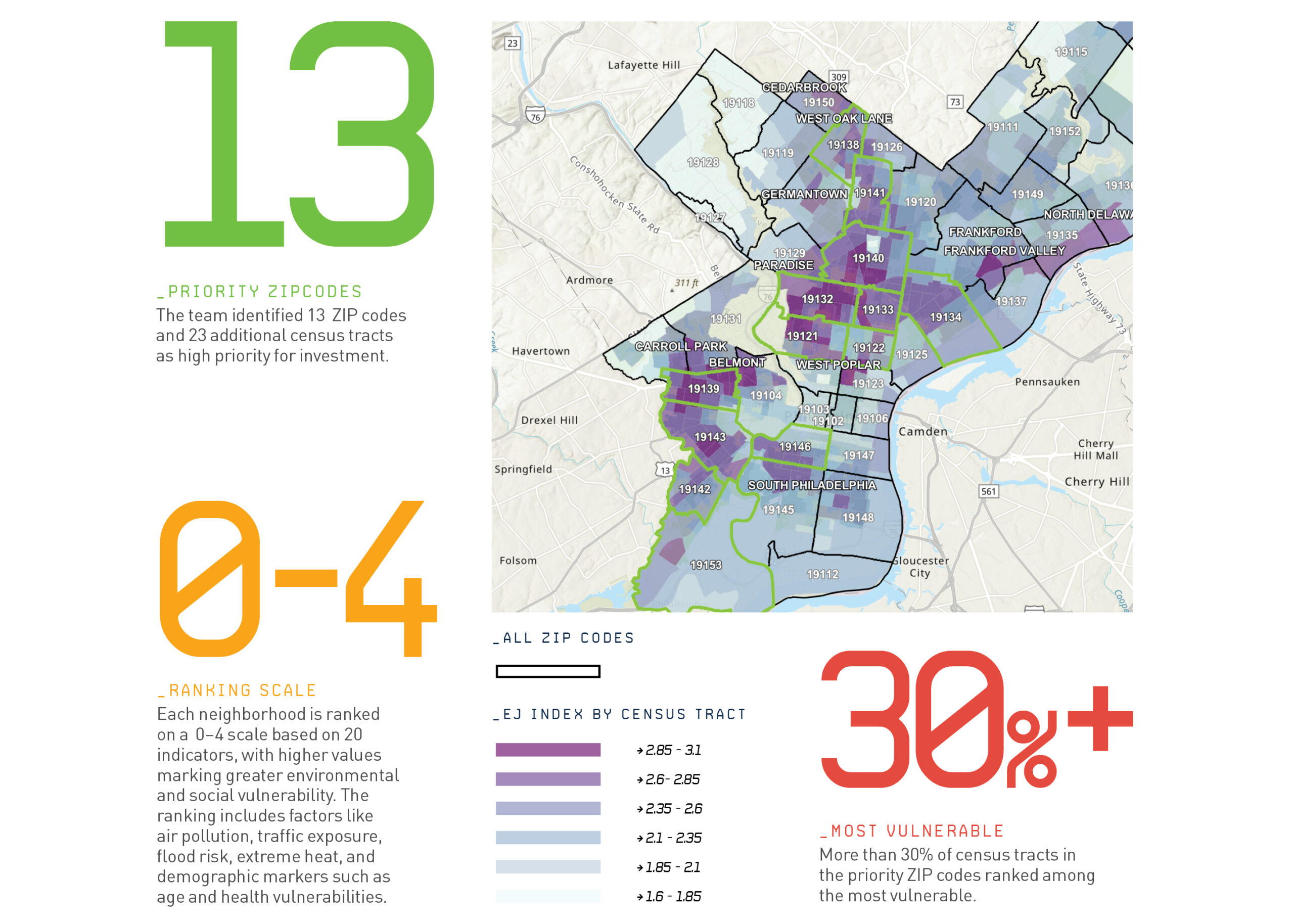
They then programmed the data into an interactive, public-facing map that reveals which neighborhoods face the greatest environmental burdens — a tool city officials and communities alike can use to advocate for targeted solutions.
To create the index, Winn Costantini, Roman Perez and Alexis Schulman analyzed 20 environmental and social factors such as air quality, traffic pollution, flood risk, urban heat and community health indicators — with each neighborhood ranked. The map has 12 data layers, allowing users to drill into specific neighborhoods and visualize how different environmental factors intersect.
Unlike traditional environmental justice measures that compare neighborhoods to state or national averages, Drexel’s index is hyperlocal — evaluating each census tract only against other areas in Philadelphia, providing a far more precise picture of environmental disparities.
“This index reveals the areas of greatest need and disinvestment,” says Costantini. “By grounding it in local data, we can pinpoint where investments in green spaces and environmental resilience are needed most.”